Day One: Duntulm to Flodigarry
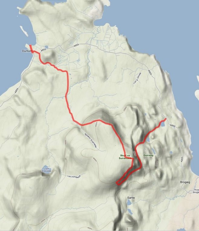 This is going to be a short day; only 8 miles or so and it’s a route I’ve developed myself to try and see the best of the Quiraing.
I will be walking this on the Saturday, the day of our arrival basically. We should get to the croft about 02:00, at which point we’ll hit the sack and try and get a few hours sleep. I hope to get out onto the route at about midday, or a little after, which will still allow us some time in the afternoon to go and do some food shopping in Portree or Broadford.
Most walks along the Quiraing use either the low path or the high path, but I’m taking advantage of the fact that I’m not limited to a circular or linear walk and I can pick and choose my start and end points (within reason). So I’m using Paterson’s end point of Duntulm Castle as my start point and I’m taking the high route over the Quiraing, then doubling back along the low route to get a view of the place from both perspectives. I then drop down to the road at Flodigarry, which is the end of day one if you’re following the route from WalkHighlands.
The start of the walk from Duntulm to the trig point on Meall na Suiramach is likely to be quite boggy and for much of the way there appears to be no obvious path on the ground to follow. Paterson’s route notes are sketchy at best and contradictory in places and I’m not a little nervous about this section of the walk. I have a river to cross, with no bridge and no real idea how wide the river is or how deep it is likely to be. Paterson says cross the river, so I’m guessing it’s a fairly trivial task, but as I said, it leaves me feeling a little nervous.
I’m used to walking paths with detailed guide books available – paths that are walked by hundreds of people every month, but this is something new. It will be a new kind of challenge.
Day Two – Cnoc a Mheirlich to The Storr
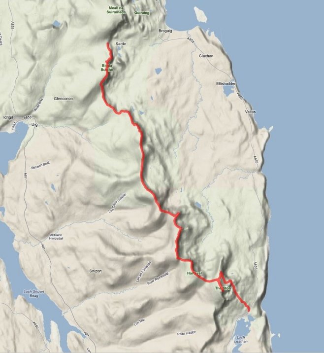 Day two is a wholly familiar challenge – one of endurance and stamina. The walk involves a similar height gain to the Yorkshire Three Peaks or the final stage of the Pennine Way from Byrness to Kirk Yetholm. Both of which I have done and both of which were more daunting in their anticipation than in their actual achievement. I’m hoping this walk will end up being the same.
As you would expect, this route is common to both Paterson and McNeish/Else. The walk starts at the Quiraing car park and from there I follow the ridge line all the way to the Storr, then down the tricky path to the Old Man of Storr and finally to the car park at the road. There are 10 separate climbs during the day with only the final climb to the Storr being optional or avoidable.
In bad weather this could be a really difficult day – there are no escape routes once you’re on the ridge and no shelter along the way. I have decided that if the weather is foul on the day I will skip this walk and do day three instead and come back to day two when the weather is more clement. I know this is sort of cheating, but in the end I have to consider safety, enjoyment and the limits of my body. The benefit of walking from a fixed location is that I am not slave to the route as I would be on a strictly linear long distance path.
If I decide to skip the climb to the Storr at the end of the ridge I can save about 400 feet of ascent, but I will decide that when I get there and it will depend on how I feel, what the weather is like and how much time I have left before Roger is due to meet me in the car park below.
Day Three – The Storr to Portree
 A much shorter day compared to the previous leg, starting with a waterfall, followed by a climb up the Marilyn of Sithean Bhealaich Chumhaing and the descent into Portree, the first proper town we encounter on the route when walked in this direction. Again the route selection for this leg is pretty much common to both books – following the cliff tops with views to the east of Raasay.
I get the feeling that much of this leg is pathless, at least up to Sithean Bhealaich Chumhaing, perhaps from there to Portree there will be a faint path created by peak baggers, but I’m not banking on it.
The route includes about 2000 feet of height gain, but this is made up of one or two 400-600 foot ascents and dozens of smaller ones, with a big drop down to sea level on the way into Portree. It could be a tiring morning if the ground is broken and pathless.
Day Four – Portree HC to Sligachan
 The first almost completely low-level day of the walk so far, with only a thousand feet or so of ascent, which is very little over 11 miles. The main feature of today though is the amount of road walking that’s involved. Of the 11 miles, about 7 of them are along the single track road (B883) that connects the various settlements with the main Portree-Sligachan road. I expect the lane will be quiet and I also expect I’ll be glad of a firm surface for a change. This feels like a day for trainers or approach shoes.
I get to finish the day at the famous Sligachan Hotel, a mecca for anyone walking or climbing on Skye and, based upon previous visits, purveyors of a truly excellent Venison burger.
Day Five – Sligachan to Kirkibost
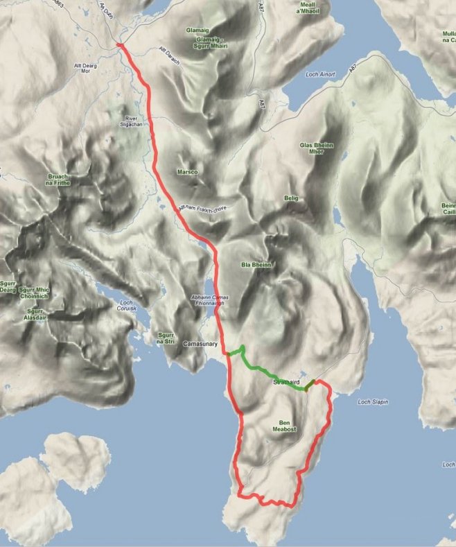 I think of all days, this is the one I am most looking forward to. Although it has rather a daunting total mileage, it uses a path I have been wanting to walk for a few years now. Both of my previous visits to Skye have left insufficient time for a proper excursion beyond the car park of the Sligachan; but on this day I head deep into the glen of the same name, beneath the feet of the mighty Cuillins and skirt the lower slopes of Bla Bheinn.
Interestingly, the Paterson book recommends bypassing much of the splendour of this glen, opting instead for a high level passage from Torrin, over Garbh-bheinn and entering Glen Sligachan just south of Marsco. McNeish/Else on the other hand, offer two possible routes through this landscape; one skirting Loch Coruisk and taking on the infamous Bad-Step and the other using an easier route straight down the glen to Camasunary. My route selection on the day is likely to depend on the weather, but to be honest, I’m pretty much decided on the easier route, avoiding the tricky traverse of the Bad Step.
From Camasunary I’ll decide how much time I have and how bad the weather is; if it’s good and I still have plenty of time, I’m heading south for Elgol and a complete tour around the peninsula. Otherwise I may cut across the Am Mam path directly to Kirkibost. Elgol has the added draw of a shop with tea room and probably cakes.
Day Six – Kirkibost to Broadford
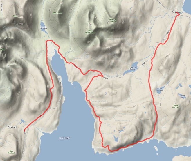 Day six was originally going to be my last day – a very long day into Broadford. But the more I thought about this, the more I felt like the job was unfinished. Admittedly this is where McNeish/Else draw the line, they go no further, even though there is still a considerable amount of Skye still to see south of this point. I will probably be without a driver after this point, as I have to take Roger home at the weekend and this severely hampers how much linear walking I can do. I did some research on the Internet though and found a series of small independent bus operators that run up and down most of the rural roads on the island. Piecing together various timetables I managed to find a schedule that allows me to continue on beyond Broadford. So today is no longer the last day!
It is still quite a big day though and involves an almost equal mix of road walking and moorland walking. There is the opportunity to cut a huge loop out of the route if things turn very bad on the weather front, but I really want to visit Suisnish, not least to bag the trig point that’s located down there. The path appears to be well trodden, with the U shaped loop making for a perfect circular walk, based on a couple of different parking places beside Loch Cill Chriosd.
Day Seven – Broadford to Drumfearn Road-head
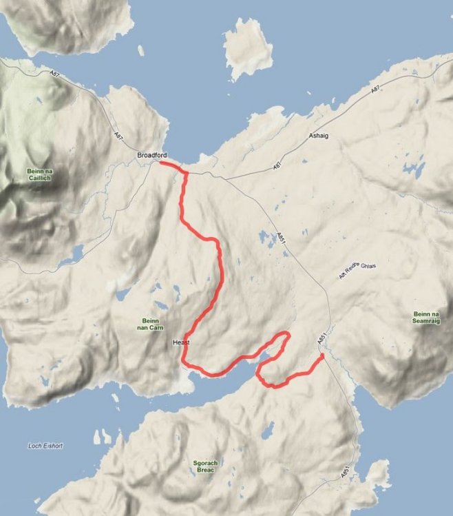 Day seven is only possible because of the local bus services. In particular Service 601that runs between the ferry port at Armadale and Skye’s bus terminal hub in Portree. Fortunately it stops in Broadford and various other places along the A851.
My plan is to arrive in time to catch the first bus coming from Armadale in the morning. I’ll park the car beside the bus stop at the Drumfearn road-head stop – Google Street View has shown me the parking facilities there. I’ll catch that bus into Broadford and then walk back to my car. This is likely to be on the Bank Holiday Monday, so I rang the bus company to make sure they were still running on that day – they informed me they were. Just to be on the safe side though, I’m using the bus to start my walk – not to finish it. It would be an awful twist of fate to find myself miles from the car, waiting for a bus that wasn’t running.
The early part of the walk is along the single-track road from Broadford to Heaste, but this is better than re-using the path from yesterday, which is my other alternative. From Heaste I follow the coast and the path described by Paterson, as far as the road at Drumfearn, where I head east to reach the car.
Day Eight – Drumfearn Road-head to Armadale
 My final day uses the same approach for transport as my previous day. Parking at Armadale I will catch the earliest bus as far as the bus stop at Drumfearn road-head and then I’ll retrace my path along the road to Drumfearn. From there it’s following Paterson’s route through Ord and down the coast to Dalavil. At some point before Dalavil I hope to pass Rambling Pete, who will be leaving Armadale today on the first day of his Skye Trail, heading North.
I’ve done quite a lot of investigation into the path from Dalavil to Armadale. Reading between the lines of Paterson’s narrative it sounds like the path is pretty bleak and boggy from the eastern tip of Loch a Ghlinne to Armadale, so I was looking for someway to mitigate this and avoid a dodgy crossing of the river that feeds the Loch. I found a couple of routes on the WalkHighlands website that I can use to take me north of Paterson’s original route, over better ground (hopefully), using paths on the ground rather than boggy wilderness. The route stays north of the feeder river after passing the Loch and cuts north over Cnoc Fall aiming for Armadale Castle and then uses paths to reach the village and the ferry terminal – the terminus for my walk!
I think Pete’s checked this route too and he may be using this to begin his walk. I hope it’s as good on the ground as it looks on paper! Otherwise I could be walking towards a torrent of abuse as we pass each other.
In the event of particularly bad weather on the day – or especially wet weather over the preceeding few days I have the option of using the road from Gillean to Kilbeg, which doesn’t reduce the mileage, but could reduce the amount of water I find myself wading through.