
The last time I tried this walk, back in August 2006, I failed dismally (see walk report here). Ever since then I have been determined to go back and finish the walk. I've done all three peaks individually and much of the path between them, but putting it all together would be the biggest walking day I've ever done. I suggested it to "Tex Gore" a couple of weeks ago and he was all for it, so we chose the date and arranged for an early start. I must admit to feeling quite nervous about this walk. For several days before I started, all I could think about was the last abortive attempt at this route and how dreadful I felt walking along the road to Ribblehead, from Pen-y-Ghent. I decided to make a slight change to the route, in an attempt to prevent the same result this time round.
Last time we walked (I was with Mike on that occasion), we set off from Horton at about 07:00 and reached the tea van at Ribblehead at about 10:40. The prospect of continuing into the wilderness for another 14 miles did not appeal and I think that contributed to me dropping out. This time I planned to walk from the little car park by the tea van at Ribblehead, across Whernside and Ingleborough and then drop down into Horton for lunch at the cafe which would be open by that time, have a leisurely rest there before completing the course over Pen-y-Ghent and back to the car. This route offers the benefit of a comfortable, indoor place to rest at lunch; important if it happens to be raining. It also means you have to carry less food and water, which of course reduces your pack weight; a very important consideration on such a long walk.
I picked Tex up at 05:30 and we arrived at Ribblehead at about 07:00. The challenge part of the 3 Peaks walk is that you have to finish within 12 hours. We were not going to be able to use the clocking system at the cafe in Horton, but we'd keep our own time and I was hoping to finish in about 10 hours.
The weather looked to be about perfect, there was no wind to speak of as we set off from the car and the sun was impeded by only a thin layer of patchy cloud. We were able to set out in short sleeves, although we'd both decided to stick to full length trousers because of the forecast for later in the day. Metcheck had predicted light showers for later in the morning, with a chilling wind on higher ground.
Of the three peaks, Whernside is the highest, but it's also the easiest in terms of ascent. The 1600 feet or so of climb from Ribblehead is spread gently across 2 miles; it provides a perfect warm-up to the day. We were treated to a train as we passed the viaduct, two lonely carriages with only a single passenger on board, we saw another one later in the day with about 10 carriages attached. It's a shame commuter trains can't flex their rolling stock to meet the changing demands of the day.
Cloud cover came and went as we climbed up to Whernside, revealing some great views across to Ingleborough and ahead to our first summit of the day. A few months ago I would probably have been waiting for Tex to catch up at this point, or we would have slowed as the incline increased. Not so anymore. Tex has been training for a mini-triathlon, in which he competed last weekend. He exceeded his own expectations during that event and finished creditably in the top third of the field. His fitness levels are now excellent and I think today's walk is another test of his own abilities - just like it is for me.
I find it hard to believe that before I climbed this hill last November (17th Nov 2007), I had tried and failed to climb it in two successive weekends earlier in the year. On both attempts I'd managed to use the weather as an excuse for not reaching the top, hiding the real reason; which was I just wasn't fit enough. This is not a challenging hill if you are in reasonably good condition. Today it felt great. It was warming the legs nicely, stretching the muscles we would be using in anger on the subsequent hills.
The 4.2 miles to the summit of Whernside took us just 90 minutes. I set my camera, on it's little tripod, on the wall and we got our first trig point picture of the day. It was warm and sunny and we both felt fit and well. We stopped for only a few minutes before pushing ahead.
Compare, if you will, the picture above to a shot we took when we walked the Herriot Way together in 2005 (click here). Tex, as you will see, is far more attached to his red socks than he is to his spare tyre! In fact we've both slimmed considerably since the 2005 photo. I'd lost most of my weight in the months leading up to that walk, but I've still managed to lose some more. Tex has done remarkably well over recent months to slim down and he's fitter and faster than I am now. That's triathlon training for you.
As we left the summit, we met the first walkers of the day coming up the path towards us. It was about 09:00 now and I guessed that these were day trippers who had parked on the road at the Old Hill Inn. There was a knot of 5 or 6 and then two or three groups who were following them. As we approached Bruntscar, probably a mile and half from the summit, we passed a family group with two young boys, one of whom was looking very fed up at being dragged up a hill on a Saturday morning when he could have been at home playing on his Wii. Without looking at each other Tex and I both came out with the same lie to the young lad "not far to go now"!
An unexpected treat was waiting for us at the farm on Philpin Lane, just before you arrive at the road and the Old Hill Inn. One of the barns has been emptied and turned into a little tea room. A stall has been set up inside the barn and a few picnic tables, providing well priced refreshments to walkers and cyclists. A wide range of fare is available as well as novelty items such as dry socks for £1.50. 70p gets you a pint of Orange squash and ice - it's great value for money in the middle of nowhere. As we arrived a large black cloud appeared above us and proceeded to dump it's load right on top of us. We stepped into the cover of the barn for 5 minutes and the shower passed by - perfect timing!
We'd had a titter on the way up here in the car, looking at the map and finding the funniest place names we could. Yorkshire has some of the best place names going and this walk takes in many of them. As we left the Old Hill Inn, which was not open yet, we came to some of our favourite places; Braithwaite Wife Hole and Humphrey Bottom. Other notable favourites included; Simon Fell Breast, Nick Pot, Dismal Hill, Foul Gutter Ridge, Slack Hill and one or two others I can't remember.
As we followed the paving across Humphrey Bottom
Ingleborough; 2 down 1 to go. The summit was very windy and the temperature had dropped significantly, just as Metcheck had predicted. I was glad I had long trousers on. I added my fleece layer and then hat and gloves and finally I felt warm again. We sheltered in the four way wind break on the summit, embarrassing ourselves with the other walkers there (details will not be revealed). Chris had made me some mini sausage rolls and she'd also packed me some little Mr Kipling cakes and we shared my snack while Tex put on his waterproof trousers. They seem to be much easier to get into than mine do - but they flap a lot more than mine do too. You could make spinnaker sails out of Tex's leggings.
I'm sure the other people in the shelter were glad to see us leave, but we had a lot further to go and I felt that time was slipping away from us. I had estimated we would be in Horton by about 12:50, or 5 hours 30 minutes after we set out. I felt we were quite a long way behind this schedule. It was all down hill to Horton from here though, so we could cruise all the way in.
Just before we arrived at Nick Pot we were passed by a couple of guys running along the path. We said our hello's and they ran on. A couple of minutes later we caught them up as they were trying to decide which path to take. One path runs almost directly east along the wall to Horton and the other runs south. "Which is the path to Horton?" one of the lads called me. I checked the map and called back "The one that runs beside the wall". They set of running again. They had one small pack between them and obviously no map or compass - what they thought they would do if the weather turned bad and the cloud came down I have no idea.
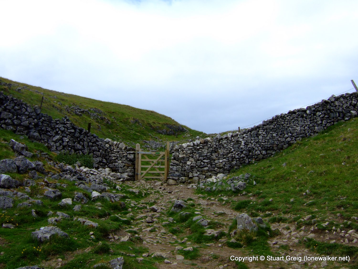
I'm going to have another moan now, so please bear with me. This area of Yorkshire has some lovely old double ladder stiles. They developed I guess due to the number of people using the paths around the 3 Peaks, perhaps a single ladder stile wasn't able to cope and was causing bottlenecks, so they built them in pairs. I don't really know. They have, in my mind at least, almost come to symbolise the 3 Peaks area of Yorkshire. My moan is; "why then has one of these lovely stiles been turned into an ugly hole in the wall, plugged by a gate?"
A gate may be more efficient, but to me this looks like vandalism. Obviously I don't know the thought process behind this decision; perhaps the stile broke and had to be replaced and the gate was maybe a cheaper option. I don't care. I shudder to think of the other possible reasons for the change. Perhaps it's more "wheel-chair friendly" and in fitting with the government's continual wish to make things more "equally accessible". Next step... concrete ramps.
The picture below doesn't show the extent of the mess left by the people who carried out this work either. The stones from the wall have been left in a loose pile on the other side of the wall - presumably they will erode over time?
Pen-y-Ghent never seemed to get any closer during the 4 mile walk into Horton. We passed through some fantastic limestone pavement and we could see a beautiful blue pool, almost like a swimming pool but much larger, on the final approach into Horton. It was 13:20 by the time we reached the cafe, about 30 minutes behind my estimate, but actually quite well timed. We'd missed the lunch hour rush and we got a table straight away.
It's not the cheapest place I've ever eaten in, in fact I'd go as far as to say it's bloody expensive! However, as Tex said, it's not what its worth, its what you're prepared to pay. Especially in a place like Horton. It was packed with walkers - there were overflow car parks for the overflow car park. There was a bikers convention just down the road, a field full of tents and bikes. So I ended up paying £1.60 for a pint mug of tea and £1.75 for a piece of chocolate shortbread. Which was just about the limit for a tight wad like me. To cap it all they don't even have a toilet! I had to walk 300 yards back up the road to use the public ones.
We spent about 40 minutes in the cafe and the tea and cake had a superb restorative effect on me. I was expecting my legs to have seized up as they often do after a long rest break, but we got back into our stride remarkably quickly. For those who want one, there is a short-cut across a bridge not marked on the map, on the way out of Horton. Just follow the finger post marked PYG, which initially follows the Pennine Way path and then utilises the aforementioned aquatic crossing structure. We aren't into short-cuts though, so we followed the road around the church as all purists will.
On leaving the village we were back in shirt sleeves; fleece and coat loosely stuffed into rucksacks - not much point refolding and securing in stuff sacks, let's face it they're going to be out again before long aren't they? As soon as we left the road at Brackenbottom the large widely spaced rain drops began to fall. The outriders, the recon units, if you like of the main shower; testing to see who will put coats on. As soon as someone's resolve breaks and a coat is pulled from a pack, the heavens open! So it was with us. No sooner had we got buttoned up and walking again, it stopped again.
We climbed to the summit, sweating in wet weather gear despite the fact that the rain held off, but it hovered over us, threatening. PYG is the steepest of the three summits, but also the shortest, in overall terms it's probably the second hardest of the day after Ingleborough.
Once again as I stopped to take a few photos, Tex was powering up the hill. I managed to keep a bit closer to him this time, at least until we were over the steepest part of the climb, but then I got talking to a guy with his two young lads. They were debating how high PYG was and I just happened to have my map open at the time, so I showed them the actual height and then converted it to feet for them.
I pushed on to find Tex quite red-faced and breathless at the summit. The shelter was full of a family sheltering from the wind, so that dad could light up a fag and fill his lungs with rubbish before the climb down again. Rather than spend time setting up the tripod again, I asked the gasper if he could take a quick photo of us with the trig point. He took two and neither of them was any good. But then it's really difficult to say that, or to then go ahead and set up the tripod to take a decent one. So being the reasonable guy I am, I just lived with it!
On the descent from PYG we met loads of walkers coming up the Pennine Way path from Horton and we passed a couple of girls sheltering from the wind just below the summit. We were to leapfrog these two all the way back to the car. In the end they tried to run past us, but we had a secret weapon!
The sun came out as we took a short break on Horton Moor. We finished the sausage rolls and the little cakes and managed to replace fleeces and coats back in our packs. The two girls came past, just as I was taking my boot of with a grimace and removing a stone. I got a look of sympathy from one of them and she said "Oh dear, are you struggling?" There was no irony or humour in her voice, just honest concern, which made the comment all the more stinging. We picked up and left a few minutes later.
We now started to meet people we had seen earlier in the day, around Ingleborough. We passed the two very fit and tough looking guys that Tex had suggested were gay - based on their shaven heads and combat pants I guess. We also passed the weirdest party of the day. A group of 5 led by a bizarrely bearded guy with the most cheerful outlook "Well hello again chaps" he shouted at the top of his voice. I wanted to ask him if he'd ever tried to hide anything in his beard - like a badger or a small child - I thought there was a distinct chance he'd be able to. Second in the party was Buster Merryfield - you'll know him as Uncle Albert from "Only Fools and Horses", yes I know he's supposed to be dead - but he can't be because we saw him walking the 3 Peaks! Somewhere in the middle of this group was a guy with eyes on the side of his head - not a word of a lie, wierd but true. Finally, bringing up the rear was a 7 foot gangly beanpole with the widest brimmed hat ever made. I didn't dare take a picture they'd have lynched me!
Just before God's Bridge we passed the two girls again. They were sitting having another short break and we just breezed past at full speed, trying to look casual and not in the least bit tired - it was a hard ruse to pull off I can tell you. There's about 3 miles back to Ribblehead from God's Bridge and we wanted to stay ahead of them all the way there. We allowed ourselves no more breaks, not for water, not for anything.
I brought out the secret weapon I had been carrying for exactly this point in the walk, the point where everything starts to hurt, the point where reserves have been drained and all that's left is will power. I brought out the JELLY BEANS! It was only a small bag. As it turned out there was enough for three small handfuls each. We took the first energy injection just after we passed the girls at God's Bridge and the effect was stunning. Instant energy!
We had our second handful just before the road section and the final few beans were handed out about a mile from the car. The last two miles went by in a blur. Our average speed over the last 1.5 miles was 3.6 miles an hour. Now that's not world record pace, but after 23 miles I was quite surprised that we managed to keep that speed up.
We could see the girls dropping behind us as we increased our pace. With about a mile left we saw them jogging, but the distance was too great and we were still increasing our pace at that time. By the time we got to the car they were running down the road - until they saw we'd made it - then they stopped running and walked the rest of the way.
Challenge completed in 10 hours and 20 minutes! Tex's view was that we should remove the 40 minutes we spent in the cafe in Horton, on the basis that if we'd started from there, we wouldn't have been able to spend 40 minutes in it. My view is that we would have spent 40 minutes somewhere else, like the Old Hill Inn, or the little tea van in the barn at Philpin.
Anyway I think 10 hours 20 minutes is pretty good for a fat git like me!
Date: 2008-06-14
Start: Ribblehead Finish: Ribblehead
Distance: 24.0 mls, 38.62 km
Height Gain: 5300 ft, 1615.4 m
Start Time: 07:10 End Time: 17:40
Duration: 10:30
Ave Speed: 2.3 mph
Region: Yorkshire Dales
Route Description: Ribblehead, Whernside, Old Hill Inn, Ingleborough, Horton, Pen-y-Ghent, High Birkwith, Nether Lodge, Ribblehead
Parking Grid Ref: SD 76564 79294
View Parking space in: OS Map or Google Street View
Walking with: Rob Powell
Long Distance Path:
2779 - Whernside (2417 ft)
2780 - Ingleborough (2373 ft)
2783 - Pen-y-ghent (2277 ft)
TP0702 - Little Whernside (Damaged condition)
TP4102 - Ingleborough (Good condition)
TP5414 - Pen-Y-Ghent (Good condition)
Click any image to open the full screen photo gallery


Walk Name: Great Whernside & Buckden Pike
Date: 2008-06-07
Distance: 15.0 mls, 24.14 km
Height Gain: 2600 ft, 792.5 m
Walk Name: Loughrigg & Silver How
Date: 2008-06-28
Distance: 10.5 mls, 16.90 km
Height Gain: 3000 ft, 914.4 m