As well as walking backwards along the route this year, my plan has always been to walk as many non-standard Wainwright legs as possible, while still maintaining as many of the usual stops as possible to facilitate baggage transfer. The table below shows my daily mileages and height gains for this walk.

In the opening sentences of his Coast to Coast guide book, Wainwright states that he wanted to “encourage in others the ambition to devise with the aid of maps their own cross-country marathons and not be merely followers of other people’s routes”. Millions of people ignored this encouragement (myself included) and slavishly walked the route he set out in 1972 – and we are all the better for it in my opinion. I doubt his route could be improved on, but it can be modified and amended, possibly without too much detriment and hopefully that will be my plan for this walk.
There were certain restrictions placed on Wainwright’s route when he was planning the walk in 1971 and 1972 – he had to stick to Rights of Way for one thing. One small error of judgement in his original route guided readers well to the north of Orton to take in the fabulous limestone pavement and the ancient settlement at Castle Folds – he received threats and letters from the local farmer for the amount of traffic this generated, across what was actually private land and the farmer installed a bull to deter walkers. AW finally had to revise the route and use the roads to the south of Great Asby Scar instead of the much finer higher alternative. The higher route is now all Open Access and I will be using this as part of my 2011 walk.
I’m sure too, there were also times when AW had to choose one fine path from A to B over another equally fine path, I now have the chance to pick the other path. The section of path between Keld and Reeth, for example, has so many possibilities that AW couldn’t detail them all. I’ll be using little trodden paths to take in Great Pinseat and using a path through the old mining scars of Forefield Rake and Friarfold Rake.

Day 1: Robin Hood’s Bay to Grosmont

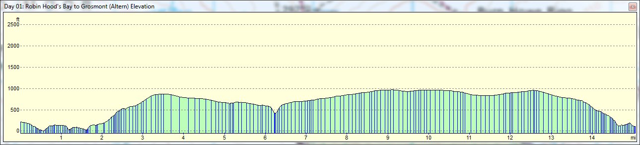
Right from the off I’m leaving the traditional route and I’m heading south out of Robin Hood’s Bay instead of north. My plan is to avoid the road walking around Hawkser and the dreadful orange bogs across the Graystone Hills. Instead I follow the Cleveland Way south, along the cliff path before heading west to pick up the start of the Lyke Wake Walk at Ravenscar. The path here is well defined, mostly firm underfoot and crosses wild, exposed, heather moorland. At the Lilla Cross I head north west to pick up the Whinstone Ridge, a well defined is somewhat muddy path that crosses Goathland Moor. At the end of this path I’ll follow footpaths into Grosmont.
On the whole I don’t expect my feet to be any drier when I arrive at Grosmont, but I will have avoided all road walking, crossed much more moorland and spent more time in wild and lonely scenery – something that is almost completely lacking from the original route through Hawkser, the Graystone Hills and the Littlebeck woods. I also manage to avoid the knee-crunching, 33% descent into Grosmont along Fair Head Lane

Day 2: Grosmont to Blakey Ridge

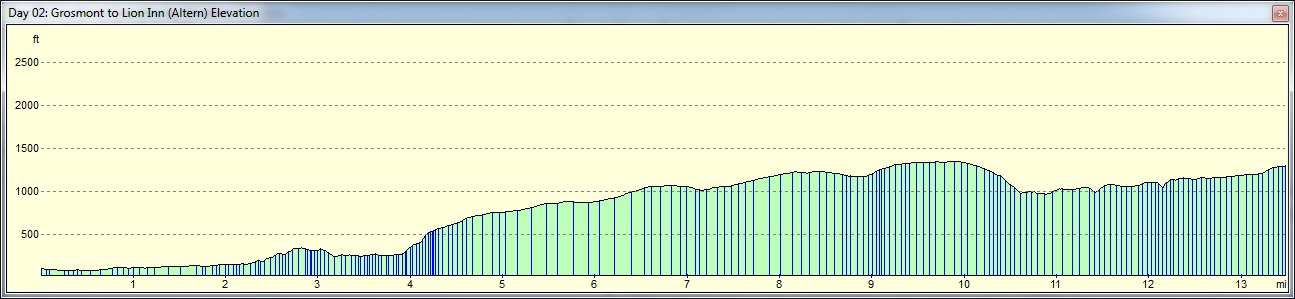
Without being deliberately awkward, there isn’t really an alternative to Wainwright’s route out of Grosmont, to Egton Bridge and beyond, to Glaisdale. Although the map suggests this route is road walking all the way to Delves – about 3 miles from Grosmont, it is in reality mostly private lanes and quiet road. The path then passes through East Arncliffe Wood, down to Beggar’s Bridge and into Glaisdale.
Beyond Glaisdale is low heather moorland and a short section of road walking to the higher moorland above Great Fryup Dale – so far we’re on the traditional route and a fine one it is too. Shortly after turning south west onto the George Gap Causeway, AW’s route heads west to pick up the road and then follows that around the head of Rosedale to meet the Lion Inn. I’ve picked a slightly different route.
I stay on the George Gap Causeway, crossing the road rather than following it and then use a footpath to drop part way down the side of the Rosedale valley and pick up the remains of the old Rosedale Railway. This runs below the lip of the valley, following its course all the way to the foot of the Lion Inn.
I save a little distance on this route, but that’s not the reason for the selection – its as much to be different as anything – and also to make full use of the railbed, which I will follow for several more miles on the next section of the walk. It will be nice to avoid the road and follow a new path.
Day 3: Blakey Ridge to Osmotherley


This route is about as standard as any Wainwright route that takes in the village of Osmotherley can be. AW of course recommended a stop at Ingleby Cross, but Osmotherley wins hands-down in any personality contest between these two stops. The village has three pubs to Ingleby’s one, it has a general store and a gear shop, which the other does not.
So I leave the Lion Inn and rejoin the old Rosedale Railway, which I follow all the way to the Cleveland Way, which in turn I use all the way to the TV Transmitter station in Arncliffe Wood, where I bear left to drop into Osmotherley, rather than right to Ingleby.
Day 4: Osmotherley to Richmond


I’m very much of the opinion that this section is one of those that you just need to get out of the way as quickly and painlessly as possible. There really is nothing to recommend this route to the long distance walker, it’s all extremely dull. Lots of fields, lots of road walking, no hills and no views.
In 2009 I tried to pick a more direct route from Danby Wiske to Osmotherley, using RoW on the 25k OS map. This ended in disaster as we ended up trying to battle through some fearsome undergrowth and waist deep nettles and brambles, along paths that hadn’t been walked in generations. So this time I’m keeping it simple.
I exit Osmotherley to the north, using the Cleveland Way and quickly pick up the C2C path, which I’ll follow to Ingleby Cross, over the A19 and then along the usual AW route to Danby Wiske. A small diversion is planned to collect a trig point on Fingay Hill, a 1/2 mile off route, but other than that it’s standard fayre.
After Danby Wiske I’m using the route suggested in the Martin Wainwright guide book, which manages to avoid a fair amount of road walking and hopefully will be on paths that are trodden much more regularly now thanks to his suggestions. So I head south out of DW and take the first RoW on the right, heading west to the minor road, then north to Brockholme, where I turn left to Moor House. From there it’s south on the RoW and then west again meeting another minor road just beside Kiplin Hall, then along the road before using more RoW paths to reach Bolton-on-Swale. The usual route over Catterick Bridge and along the south bank of the Swale takes me into Richmond.
Day 5: Richmond to Reeth
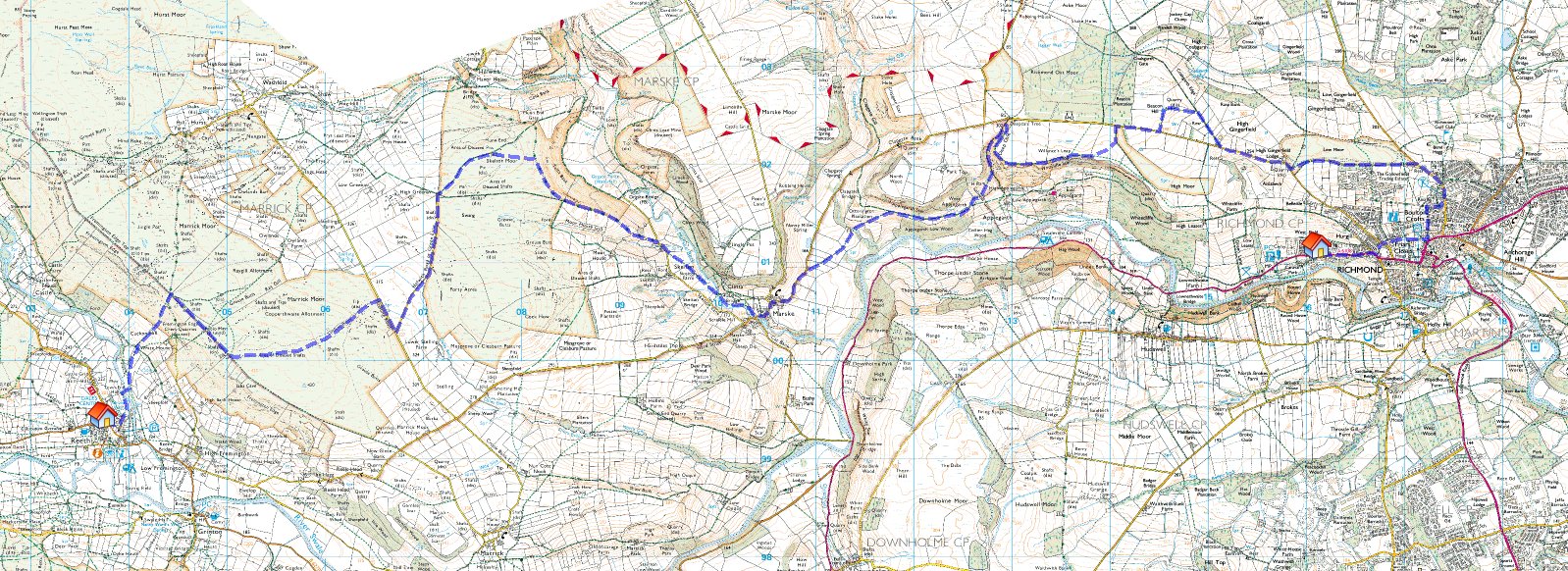

Today’s leg is even more non-standard again. The usual Marske, Marrick, Reeth route is all a little dull for my taste – too many fields and not enough moorland. And moorland is something that’s not lacking here abouts – we’re approaching the edge of the Yorkshire Dales and some of the best heather moorland in the country. It didn’t take much route massaging therefore, to divert north and pick up Skelton Moor (with the added bonus of a new trig point for me) and Marrick Moor.
I leave Richmond on the northbound Ravensworth road, then turn west to collect a trig point at Beacon Hill, then drop down to the road and find the monument on Willance’s Leap, which stands high above the usual C2C route. I then drop down to Marske, but instead of continuing south west I head north west, beside Marske Beck and up onto Skelton Moor. I then use a minor road (Helwith Road) to get to Marrick Moor, which is crossed on a little known track beside a series of old mine shafts. That leaves me on Fremington Edge, looking down on Reeth which I approach from the north on a number of footpaths.
This rather convoluted route adds about 3 miles to the usual leg, but travels higher, quieter paths and offers me access to places I’ve not visited before.

Day 6: Reeth to Keld

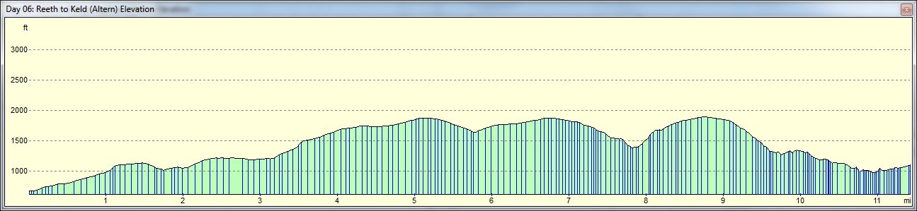
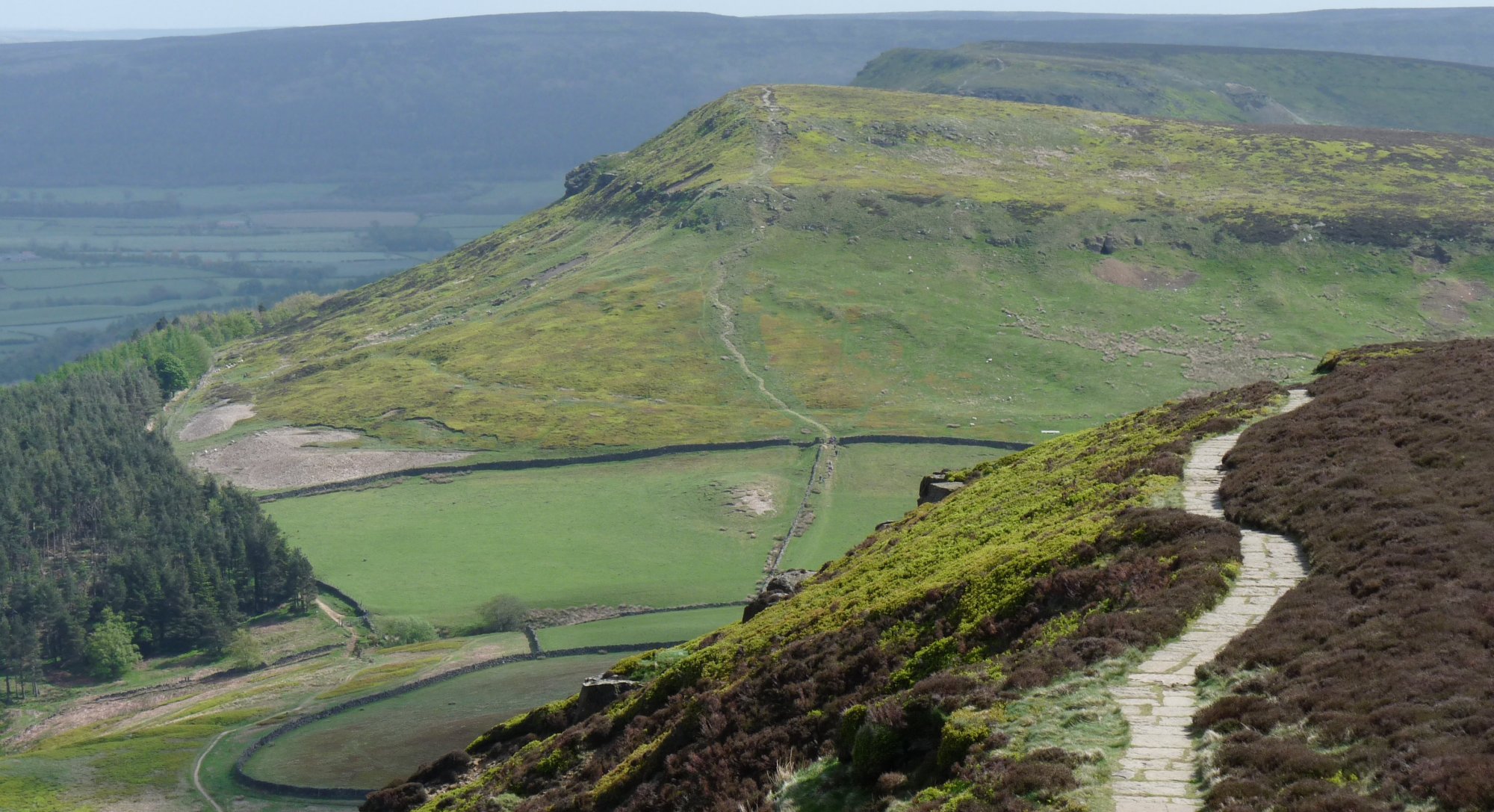
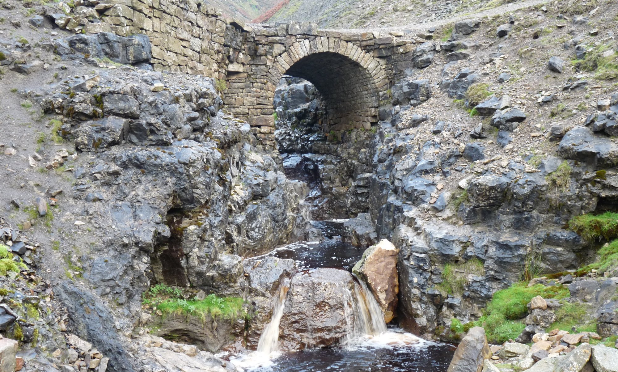
I leave Reeth on the B6270 – passing the lovely Reeth Bakery, where I would hope to collect something tasty for lunch – and leaving the road just beyond the school where I take a footpath through the fields to Reeth Low Moor . I skirt the southern edge of this, as far as Cringley Bottom (great place name), where I turn north west, along the wall to meet the minor road. Crossing this I pick up the wide track that leads to Great Pinseat. From there I head just south of west, down to and across Flincher Gill where I pick up a little known track through the old mining scars of Friarfold Rake. At the end of this path I can drop down Gorton Hush and follow the track to Blakethwaite Mill, and from there it’s the standard C2C route back across the 4WD track to Swinner Gill, Crackpot Hall and Keld.
Keld is my most favourite of all Dales villages and I am staying at Keld Lodge – a place to relax, drink the fine Kelda ale and meet the other 28 or so C2Cers staying in the village – they all come here at some point. Most of them have just slogged their way through the bogs over Nine Standards and it will be nice to get some idea of how bad they are before I get to them on the next leg.
Day 7: Keld to Kirkby Stephen
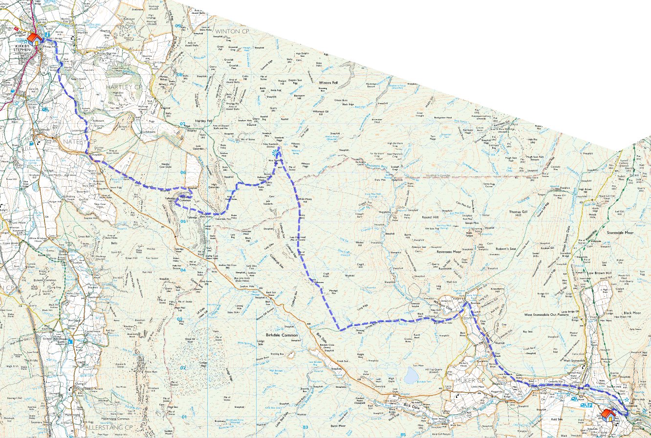
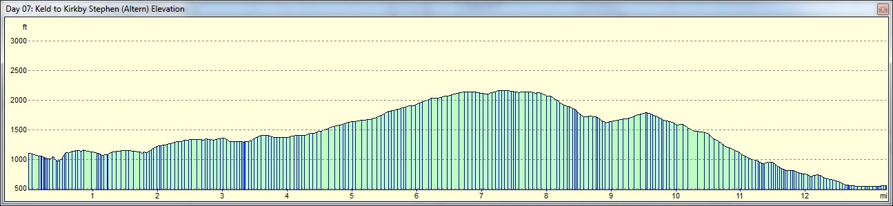
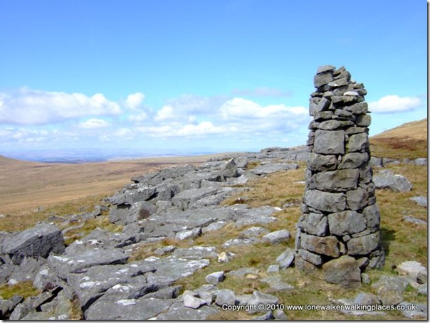
Most of today’s route is going to be fairly traditional, leave Keld and follow the footpath up Whitsun Dale to Ravenseat and then west, passing the shelter of the shooting hut, before turning north and following the path that takes in the old Millstones Pillar, Lady Dike Head, the peat bogs of White Mossy Hill and finally the trig point and the cairns on Nine Standards Rigg.
At that point, the traditional route is abandoned and instead of going west towards the road head above Hartley, I’m going south and then west to Rollinson Gill and then south again and west to bag the summit of Tailbridge Hill – a Dewey.
From there it’s alongside the wall until I meet the B6270 and then north through Lockthwaite and beside Ladthwaite Beck to Bollam Bridge and then down to meet Frank’s Bridge and on into Kirkby Stephen.
This route means I get to avoid several miles of road walking and I get to bag another Dewey, as well as taking the path less trodden, one of the underlying aims of this C2C for me.
Day 8: Kirkby Stephen to Shap


Over half way now and approaching the Lakes, I’ve had three short-ish days, but today’s leg into Shap is just shy of 20 miles and has a great mix of stunning scenery including huge tracts of…. open moorland and some splendid limestone pavement.
I leave KS on the traditional AW route, dropping down to Smardale Bridge, where I deviate slightly. AW’s route cuts back north east and then north west, swinging around Begin Hill and across Ewefell Mire. I intend to head south west and then due west from Smardale Bridge, passing Brownber and then using the road to rejoin with the traditional route as it crosses Ravonstonedale Moor – reaching the road about 1/2 mile south west of Sunbiggin Tarn. Here I will hopefully have a chance to meet the writer of one of the walking journals I host over on Walking Places, Brian, the Benwick Rambler. He’s doing his first C2C crossing, in the more usual direction of course and we should pass at approximately 11am at around Sunbiggin Tarn.
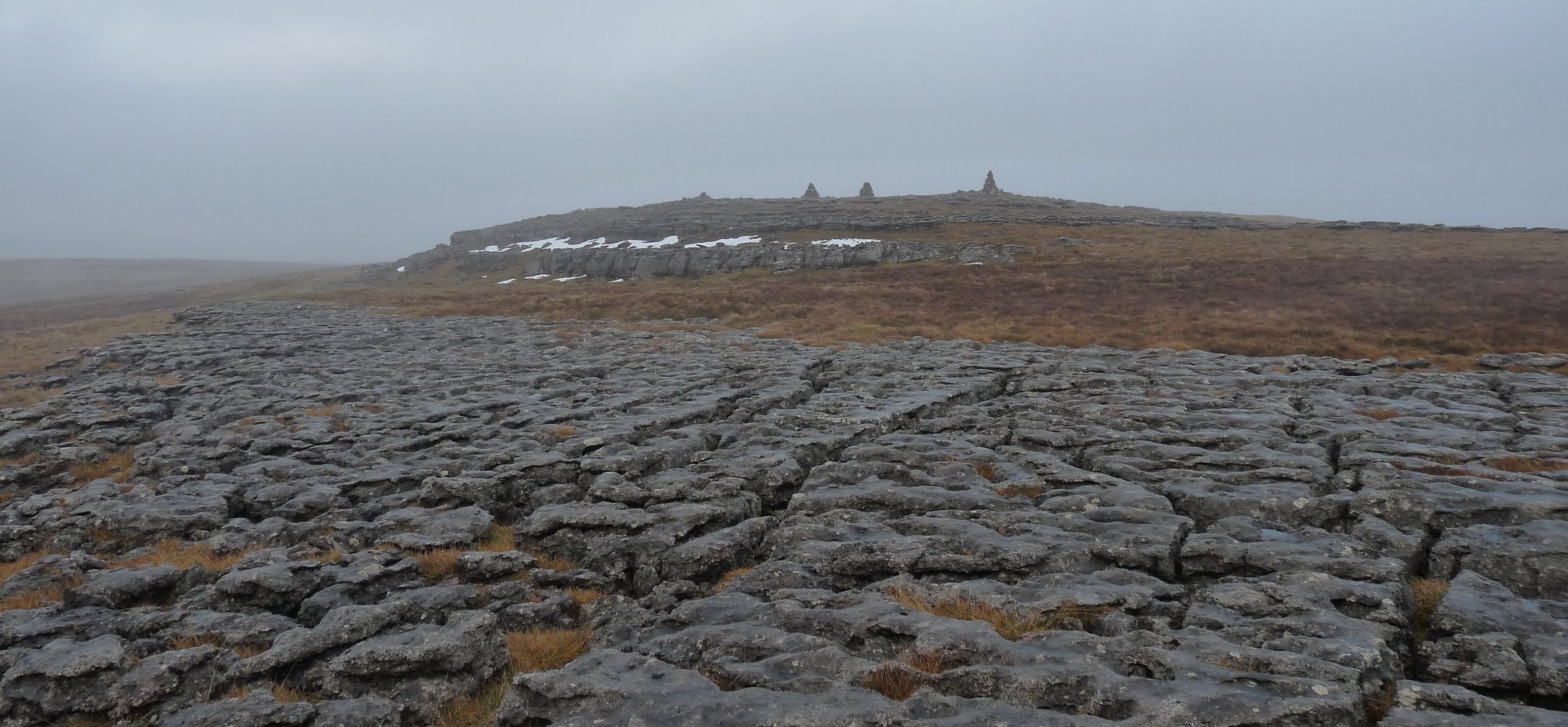
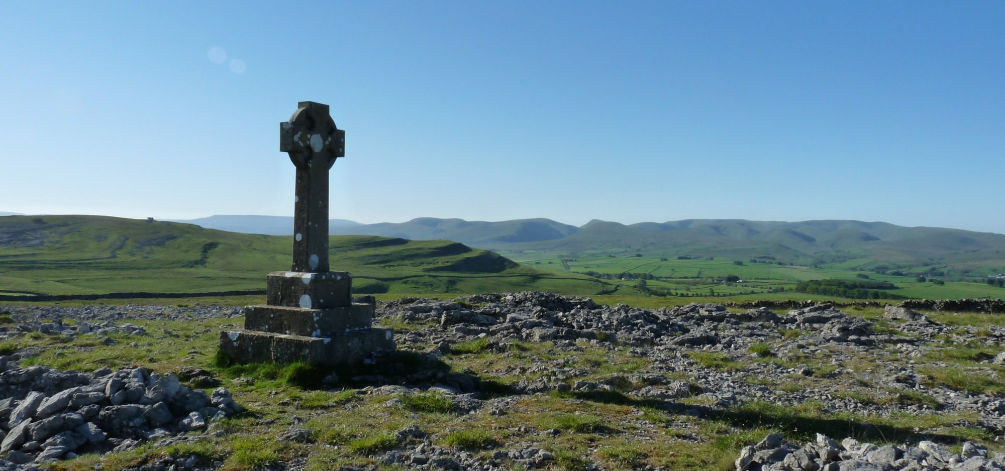
After a natter with Brian I’ll be leaving the traditional route, to try and use the route AW first suggested when he published the walk back in 1972. From the tarn, rather than head west past Sunbiggin Farm, I’ll be heading north, past Great Kinmond, up to the limestone pavement of Great Asby Scar. I keep north until just before the junction of bridleways. At NY 668097 I turn left, beside the wall initially, but then heading straight for Castle Folds, the remains of an ancient settlement. From there I head north west and then west, past the Victoria Jubilee monument (at NY 636100) and down to the road.
AW tried to include this in his original route, even though he knew it to be private land. He assumed, wrongly as it turned out, that the landowner wouldn’t mind the occasional rambler crossing his land. The farmer was rather annoyed, especially as the number of people increased and a few months after publication AW began to get letters complaining of the intrusions. The farmer even placed a bull in the field to deter walkers and finally AW had to amend the route. The alternative was to use the roads and field paths to the south of the limestone pavement – a much poorer alternative.
Even Chris Jesty’s 2010 revision of the AW route doesn’t include the high route as a possibility. Even though it is now all open access and perfectly legitimate to use, Jesty still suggests the road route through the farms. He is concerned that there is a wall to cross, but I’ve walked here before and it can be done without climbing any walls. The map below shows the route I’m using; the little flags show the position of gates or stiles that make access possible.
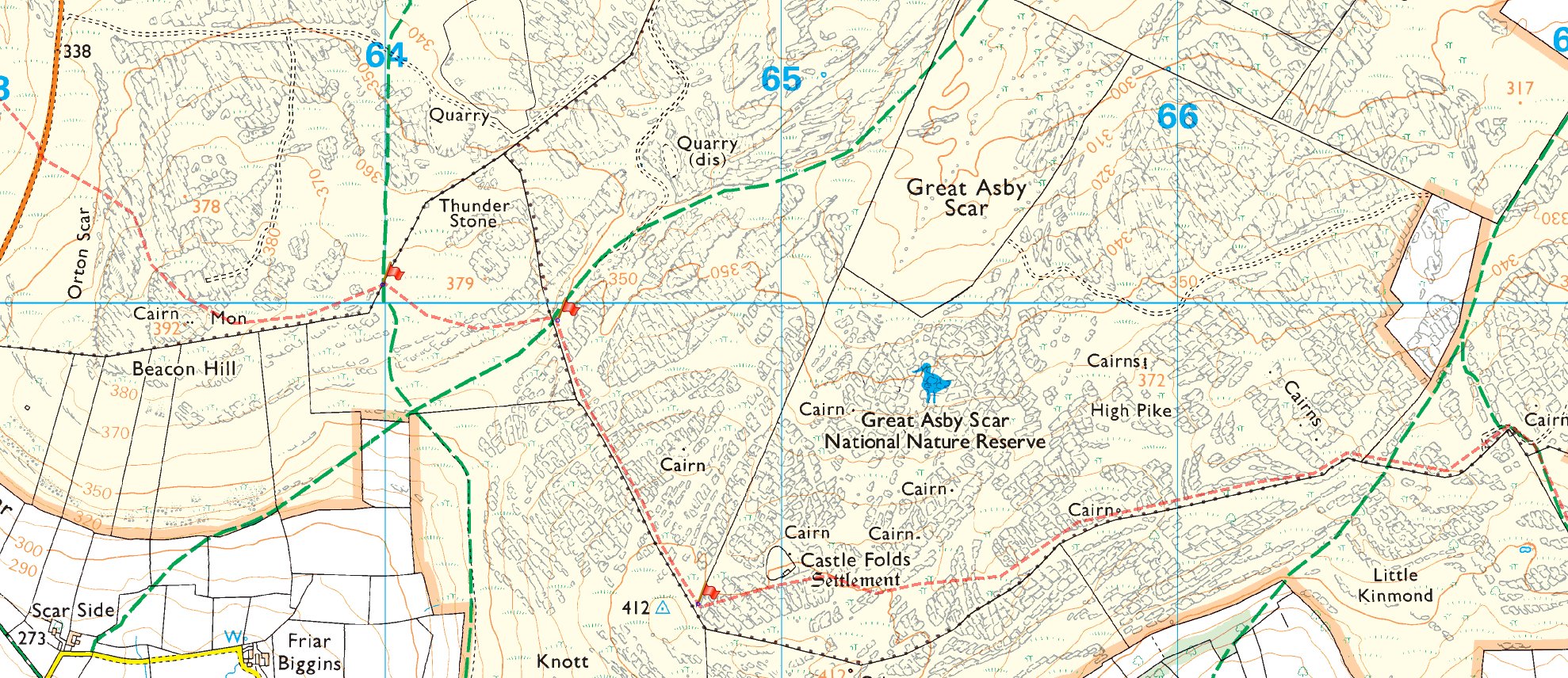
From the road in the far left hand edge of the map above, I head west, back on the traditional AW route, at least as far as the wall corner at NY 608108, there I continue directly west, passing the King Charles monument at Black Dub as far as the trig point on the edge of the fell, overlooking the M6. Then it’s north again to Oddendale and the AW route through the quarry and into Shap.
Day 9: Shap to Patterdale
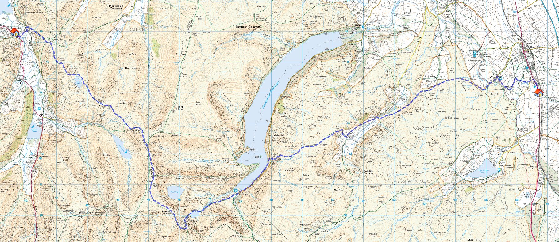

I’m finally into the Lakes, or at least Shap, which is certainly the gateway to the Lakes as far as this journey is concerned. I will be able to see Kidsty Pike from the front door of the B&B as I set out – weather permitting of course – almost close enough to touch.
The Lakes is where I go “off course” in a big way – my intention was always to make the next few days as non-standard as possible – use paths I’ve never been on before, revisit old favourites and pretty much try and be as different as possible.
I leave Shap at the south end of the village and use a couple of dog-leg paths to reach Keld, from where I head south west along the minor road before picking up the footpath beside Swindale Beck. This is new to me and I may try and make a short diversion to collect the Outlying Wainwright fell of Langhowe Pike. It’s back on the road for a short way to Swindale Head and then up and over the Old Corpse Road (bagging the Birkett of Brown Howe on the way).
The Old Corpse Road deposits me beside Haweswater where I use a thin path through the bracken to reach Mardale Head. I’ll continue south west up the rocky path to Small Water, Nan Bield and then sharp right up to Mardale Ill Bell and beyond to High Street, my most favourite Lakeland summit. As I drop down from there to Riggindale Head I rejoin the AW route around the Knott, down to Angle Tarn and into Patterdale

Day 10: Patterdale to Grasmere


Stopping in Grasmere is a first for me. On my two previous C2C crossings I’ve jumped straight from Borrowdale to Patterdale, using slightly different routes on each occasion, but skipping Grasmere both times. In order to extend my time in the Lakes this year, I decided to stop here – despite the expense.
I’m resisting the Helvellyn via Striding Edge option from Patterdale and even the St. Sunday Crag option. Both these would provide a great days walking I know, but they also mean quite short days and that is not my intention for the next couple of days. So instead I walk south out of Patterdale, following the A592 for a mile or so until Deepdale Bridge. Here I take the ridge line path up to Hartsop Above How and Hart Crag. I then use the eastern side of the Fairfield Horseshoe route (Dove Crag, High Pike, Low Pike), all the way down to Low Sweden bridge. I now head north west skirting Rydal and following the footpath all the way to Town End and into Grasmere from the south.
Even this circuitous route is only 12 miles and I will have a few hours in the late afternoon, evening to sit and relax in a comfortable pub somewhere and watch the grockles.

Day 11: Grasmere to Stonethwaite


I head south west out of Grasmere, along the minor road, past the Dale Lodge Hotel and then turn right, off the road, onto a footpath up Kelbarrow and onto Silver How. Between this Wainwright and that of Blea Rigg, are three Birketts I’ve not done before; Lang How, Swinescar Pike and Castle How. There is a rough path linking these together and dropping down to Stickle Tarn. Then it’s up onto Harrison Stickle and a circuit of the Langdale Pikes before striking off across Martcrag Moor to Stake Pass. From there I’ll follow the Cumbria Way all the way to Stonethwaite.
Langstrath valley is something I’ve stood high above and looked down into on a number of occasions, but never actually walked through it, so this will be my first opportunity. It should be a good path (after the boggy section over Blea Rigg) thanks to the Cumbria Way.

Day 12: Stonethwaite to Ennerdale Bridge

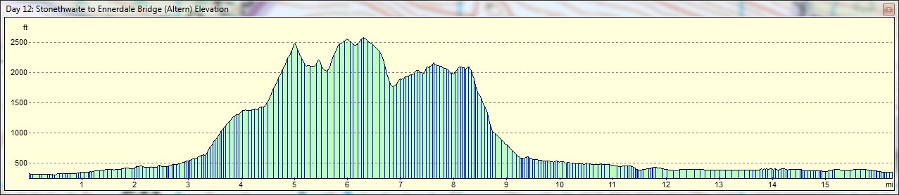
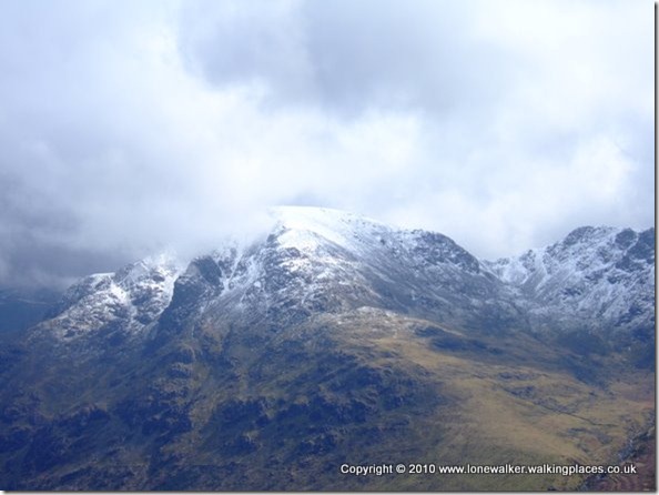
Leaving Stonethwaite I head north west to reach the B5289, which I turn left onto, as far as Strands Bridge where I use the Allerdale Ramble path to reach Seathwaite. I’ll head due south from the village to reach Stockley Bridge, a truly wonderful piece of old stonework above a rocky river. The path now heads steeply up beside Styhead Gill to reach Styhead Tarn. Here I’ll turn sharply north west to pass between the Gables over Windy Gap. I’ll contour left here around the lower slopes of Great Gable; over Kirk Fell to Looking Stead.
There’s been quite a lot of height gain so far and I’ll need to decide at this point whether I have the legs for Pillar or not. If I do there’s a path that runs up to the summit and then down White Pike into Ennerdale Forest below. If I don’t have enough juice in the tank then I’ll take the path from Looking Stead down beneath Pillar Rock to the 4WD track that serves Black Sail hostel.
Both these options join up just before High Gillerthwaite Youth Hostel and from there its traditional Wainwright all the way back to Ennerdale Bridge.
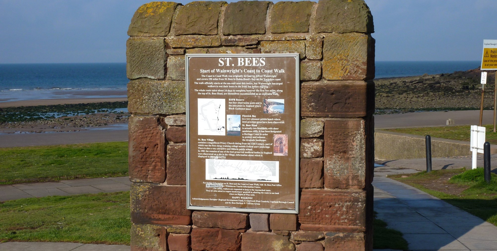
Day 13: Ennerdale Bridge to St. Bees
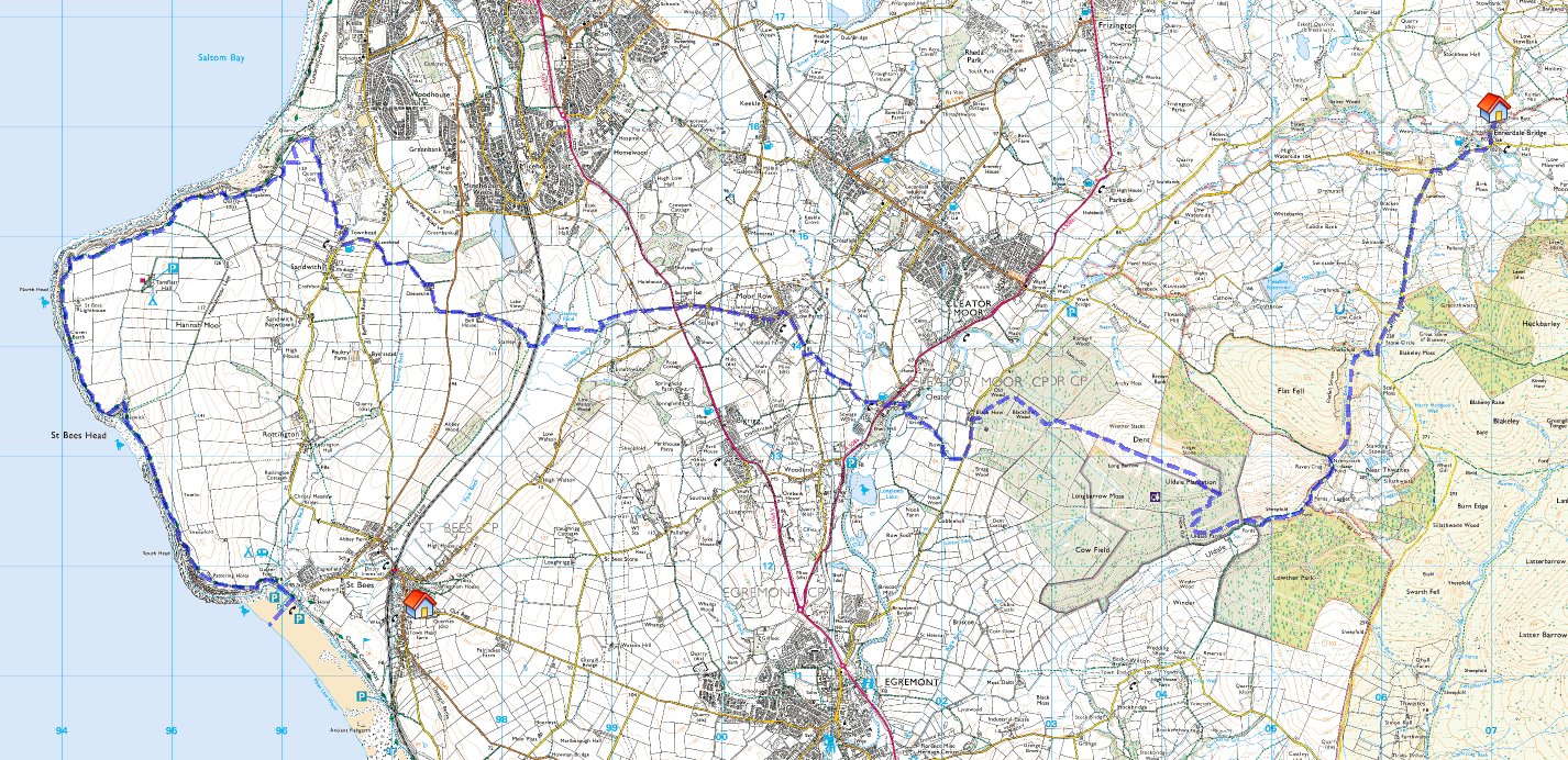
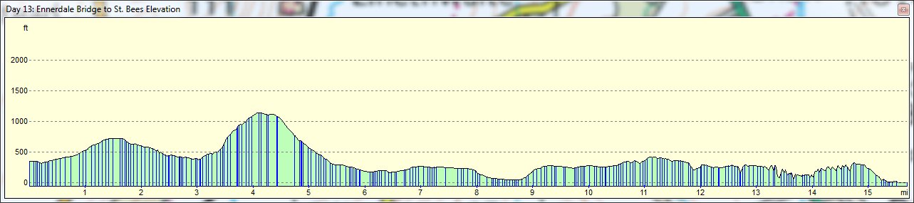
I don’t expect to be doing anything too non-standard on the final day. I expect to be a bit knackered after yesterday’s monster walk over Pillar. So its south west out of Ennerdale Bridge, through Nannycatch, over Dent and down into Cleator.
I’ll be avoiding the dog-shit encrusted cycle path around Moor Row and opting for the road through the village instead. I was looking for someway to avoid the really horrible boggy section around Stanley Pond, but that’s not easy.
At Sandwith I’ll also be diverting to photograph a trig point I bagged in 2006 and didn’t manage to get a good picture of thanks to the farmer seeding his field and me not wanting to jump a barbed wire fence in his full view. Then its back along the coast path into the village.
3 thoughts on “Coast to Coast 2011 – Selecting a Route”
I remember, I did the Coast to Coast on a east to west crossing back in 1992, that I did from Robin Hood’s Bay to Park House nr Ingleby Cross via Lyke Wake Walk and staying overnight at the Wheeldale Lodge YH and Head House Farm in Church Houses. it is a good idea and there is a good campsite at Goathland called Abbot’s House.
Jane, glad you found my journal useful, I tried to include all the elements that I would have found useful in other journals, especially as it was my first long path. I also found walking to be incredibly addictive, to the point that I can almost count on the fingers of one hand the number of Saturday walks I’ve missed over the past few years. I bet once you’ve walked the C2C you’ll be looking for another walk the following year too 🙂
You can send me your planned itinerary by email if you don’t want it broadcast on here and we’ll see where out routes cross and try and arrange a meet. I’m already meeting another reader near Sunbiggin Tarn for a spot of lunch on the 19th June. My email addres is stuart @ walkingplaces . co . uk – just remove the spaces obviously 🙂
Where are you based? If I know of any walks locally I’ll let you know.
Hi – found your site while researching for my C2C 2011 walk – the first walk which I have just started to announce to friends and family!!! I am now in training and grateful for the time you must have spent sharing experience…
I am setting out from St.Bees on 15th June 2011 so we may cross paths around the 19/20th and if it happens to be near a pub – I will buy you a pint as your site has given me such insight and great tips…
New to walking I am building up with 1-2mile walks each evening with longer walks at weekends and finding it quiet an experience! Having posted my charity page and got my first few donations I am now committed…. so here goes and cant help thinking I have found a new hobby
I’ll check back over the next few months to see your new posts – but any weekend walks that you would recommend as good training would be welcomed!
Regards
Jane Seeley
http://www.justgiving.com/jane-seeley