This topology map of the Lake District fells came around after a chance conversation with my walking friend Matthew King. He was creating a bespoke map of the Wainwrights, something that would show the hills in relation to each other and where it was possible to link them with a ridge. His map was very functional, but not quite as aesthetically pleasing as I would have liked. Click here for a view of his map.
It was a great idea and I sort of stole it and worked it into something that fit my needs a bit more closely. I wanted to show all the major hill lists on my map and I wanted a tick list section that I could update once I’d visited the summit. I also wanted to be able to hang it on the wall as a visual reminder of my progress, so it also needed to look good.
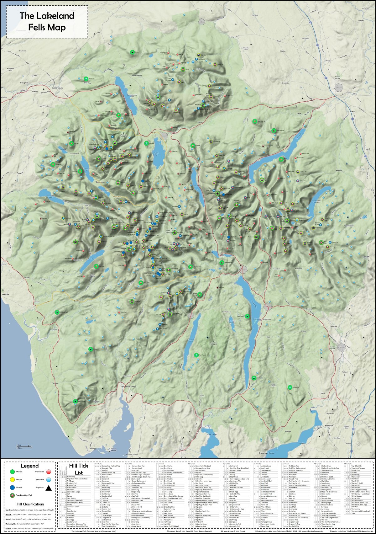
I spent a lot of time, using a variety of tools coming up with the map you can see over on the left of this page (clicking the map will give you a bigger version to look at). It includes several hill lists; as well as the obvious Wainwrights it shows the most common bagging lists of the Marilyns, Nuttalls, Hewitts as well as some of the less well-known ones such as the HuMPs, Deweys, Birketts and Wainwright’s Outlying Fells. The fells are represented by coloured circles and they are overlayed on a Google Terrain map which shows roads, lakes, and the hill contours.
Each hill group circle is slightly smaller than the last and is a different colour, so it’s quite easy to identify hills which fall into multiple classifications. As an added bonus I’ve added all the trig points (all the pillars at least) as well. This now provides a useful overview of all the Lakeland Fells, not just the once described by Wainwright.
At the bottom of the chart is an alphabetical list of all the fells, each with their own check box which you can tick off to show your progress; this covers all the major tick lists, but there wasn’t really room to include all the ‘other’ hill lists. See below for an example of the tick list section of the chart.


For those of you who aren’t familiar with the British hill lists, here a quick run down of what’s included on the wall chart:
- Marilyns: UK HIlls with a 150m drop
- Hewitts: UK Hills over 2000 feet with a 30m drop
- Nuttalls: UK Hills over 2000 feet with a 15m drop
- Wainwrights: The 214 Fells classified by AW
- Wainwright Outlying Fells: The subsequent outlying fells classified by AW
- Birketts: The 541 Fells classified by Bill Birkett
- HuMPs: All UK Hills with a Hundred Metre Prominence
- Deweys: UK Hills between 500m and 2000 feet with a drop of 30m
Above right shows a zoomed in view so you can see how the map works in a little more detail. Notice that High Raise (almost exactly centre image) is a Wainwright, a Nuttall, a Hewitt and a Marilyn all shown with concentric coloured circles. The black triangle in the middle means it also has a trig point on the summit.
Printing
You will receive a JPG image of the map, not a printed version, but this means you can choose your own size and format, using one of the many places on the web that will print images for you. I have an A0 (1.1m high by about 0.8m wide) poster on my office wall, and it looks fantastic.
There are a number of online services that will print the file for you – I’ve tested both VistaPrint and InstaPrint, which offer lots of different types of printing options.
9 thoughts on “Lake District Fells Map”
Hi there, I just bought your excellent map.
I am looking for the Birketts in particular and although they are marked in blue I didn’t realise that they aren’t actually on the list. Do you have a list of the Birketts? I should have looked closer
Hi Pixie, unfortunately there are so many Birketts, the hill check list at the bottom of the map would have taken up far too much room, so I had to settle for just highlighting them on the map. You can see the full list of Birketts, and track your progress through them, on the Hill Bagging Database at this page: http://www.hill-bagging.co.uk/search.php?qu=B&ty=B
Since Kelly identified that the previous service I was using, no longer produces A0 posters, I have updated the online printing services links. I have ordered posters from both these services and they produce good quality posters. They both run regular promotions, so look out for deals, especially close to Christmas and other traditional ‘sale’ periods.
Hi Stuart
Where did you get your poster made as Photobox saying they cannot make it A0. It looks like 45 by 30 is there largest poster size? Thanks
Kelly
Hi Stuart,
This is an excellent idea, just about to purchase, checking this is all still live given most recent comments are 2012?
Also would love to see a shot of your wall mounted A0 poster, gague how it looks.
Cheers
Michael
Michael, thanks for the interest. Map is still active and has proven quite popular for the last couple of years. Email sent with pics of the map on my wall.
Hi Stuart, i would like a copy to please, i will send over the money shortly! Regards Rick
Hi there Stuart, I’m interested in a copy of your very impressive map here…. Can you produce it without the “Other Fell” light blue circles? No worries if that’s not possible, or an enormous amount of work. How can I pay you your fiver? Paypal?
With thanks, Alistair
Hi Alistair
It’s all done in Visio, so removing the Other Fells is dead easy, just switching off that layer.
Yes, ping me a fiver via PayPal to my email address (stuart at walkingplaces.co.uk) and I’ll email a PDF file back.