Choosing a route along a prescribed National Trail may seem like a pointless exercise, or rather the re-enactment of a task that has already been done for me by the trail planners. However, things are rarely so simple and although I’ve walked several waymarked trails now, I have rarely followed them blindly and without consideration.
I am not a purist when it comes to walking Long Distance Paths. Although I like to leave from the official start point and arrive at the official terminus, the route in between is often modified slightly to meet my own requirements, to take in particular places off the main route, or to avoid boring or potentially boggy sections.
I came in for some criticism from two guys I walked with on one section of the Pennine Way, who felt that my avoidance of a notoriously boggy section, in favour of a tarmac road and then a forestry track, was an unwarranted deviation. They went as far as to say that I hadn’t actually walked the Pennine Way because of this. In purists’ terms they were right. Unlike, for example, Wainwright’s Coast to Coast path, the Pennine Way and southern Upland Way are prescribed routes; the C2C is a suggested route. If you deviate away from AW’s route you can still claim to have walked ‘Coast to Coast’, but should you deviate from THE Pennine Way or THE Southern Upland Way (the capitals are important there), then can you really claim to have walked the route? Personally, I don’t care.
I walk for the sheer pleasure of walking, not to follow the green diamonds on the map. Although I subscribe to many walking-related tick lists, such as the Wainwrights (the 214 summits in the Lake District described by AW) and I am painfully pedantic about the accuracy of my collection of these, I do not apply the same sort of thoroughness to my long distance paths.
As a result, route selection along the Southern Upland Way has taken up quite a bit of my time.
The first thing I did was to download the full route from the Long Distance Walkers Association website. This is then loaded into Memory Map on my PC. The LDWA is an incredible resource and the annual membership fee of £13 is negligible when compared to the information that is made available as a result.
Once the route is loaded on my PC I checked it against the guide book, for any changes, modifications, diversions etc. In this case, it was a good match. Unfortunately, the maps I have for Memory Map are a few years out of date and the route has been moved slightly over time. This means that in some cases, the route I needed to take didn’t match the green diamonds on my map, but this is no great problem.
I now look for hills or trig points along the route and any that are within a mile or so of the route, that could be easily diverted to if I wanted. This is all achieved in Memory Map and results in a route with trig points and hill scattered along its length. I then whittle these down to the ones I easily include without adding too much distance or height to the day.
The route needs to be tweaked for accommodation as well. If the B&B or Hotel I’ve chosen isn’t exactly on the route, I may need to leave the route early to find it. I may also skip some sections of the route while doing this, but this isn’t done to create shortcuts, it will only be done to avoid long road walks or especially dull lengths of the path.
My SUW Deviations
The first deviation I make is into Stranraer. The official route swings around the south of the town, using minor roads and farm lanes.

All the journals I’ve read say that this is a boring road walk with uninspiring views, a section to get out of the way. So I’m going to skip it. I leave the path at Ochtrelure and head into Stranraer and when I leave the town I’m heading east to pick up the path at Big Plantation. I’m using the most picturesque route I can between these two points.
On the other hand, as I approach New Luce at the end of the second day, there is the opportunity to skip about four miles of moorland walking and replace it with a mile and half of road.

This smacks of short-cutting to me and it’s not something I’ll be doing. Double-standards perhaps? I don’t think so. It’s a fairly short day anyway, so I shouldn’t be too tired or time restricted and the moorland sections are generally to be savoured in this early section of the walk where the majority of the scenery is farmland and minor roads.
The next major change to the route is at the start of the fourth day. This is a long, tough day; 26 miles and 3100 feet of ascent if you follow the path slavishly. This early in the walk it will be a physical challenge and one that I’d like to make slightly easier if I can.
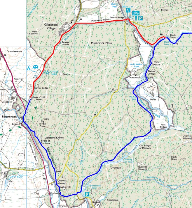
So rather than following the blue route, that heads south for a long way, before swinging north east again, I’m considering heading north from the hotel, along a quiet lane and re-joining the path at Stroan Bridge, where I understand there is a small track beside the river that links up with the SUW route. This is certainly a short-cut and will save me about 2 miles on the day. I will see how I feel the night before and make a decision then.
The next diversion is a huge one, changing almost half of the day’s walking into Wanlockhead for a completely different route. The main reason for this is to bag a trig point and two hills; one of which is a Marilyn.

The red route above is the diversion, with the blue route being the official path.
That will be the final large change in the route. Over the course of the walk I make about 20 small diversions for trig points and hill summits, but these mostly divert up to the summit and back down, re-joining the path at pretty much the same place as I left it.
6 thoughts on “Southern Upland Way 2013 – The Route”
I’m another one in complete agreement with you (and those variations your proposing to the SUW look completely sensible to me!). When Mick & I walked the Pennine Way, we met a chap in Alston who gave us quite a lecture about the fact that we wouldn’t have walked the Pennine Way because, even though we started in Edale and walked every step to Kirk Yetholm, we deviated from the route in a few places. He couldn’t quite grasp my point that, given that we weren’t going to claim a certificate, qualification or other honour for doing the walk, we could walk whatever route we chose (and besides which, our prime objective at the time was to walk continuously from Land’s End to John O’Groats, not to be true to the official route of the Pennine Way!).
I’m definitely of the view that the important thing is to be out there walking. The route you choose to take is entirely up to you.
Thanks Gayle, another vote for common sense 🙂
I took the old way at the start of the Pennine Way over Kinder, were now it goes by Jacobs Ladder. Wainwright had a loop, which is marked on the trail but I followed the path the whole way till the Bowes loop. I went to the pub in Bowes. But I agree its fine to deviate. After all in the USA PCT walkers are likely to need to change routes due to fires etc ,and other trails have diversions due to erosion. Its what it is. Start and finish; the rest is up to you.
The LDWA have a National Trails register. I have often wondered (never been bothered to check!) how much deviation from the official path is allowed before you don’t qualify for a trail completion.
Fortunately I’m not ticking off the NTs, there are too many that don’t appeal to me, so I’m of the mind that I’ll never do them all 🙂
I’m hoping that by cutting my ties to the baggage couriers I can start to ‘wander’ once I’ve done all the waymarked trails that I want to do. TGO challenge in 2015 maybe?
I’m entirely with you on that one! When I did the Pennine Way, there were 3 or 4 sections where I deviated for one reason or another – doesn’t matter to me, Dixie and I still walked to Scotland!
Although I haven’t yet done the SUW, I also have planned a route – I tried to start it a couple of years ago but got thwarted due to illness – and interestingly I have exactly the same deviation in as you, going through Glentrool village to get to Stroan Bridge.
Don’t know if you’ve ever read ‘Pennine Way Walkies’ by Mark Wallington, but he also comes to the conclusion that slavishly following the prescribed route without giving any thought to other experiences that may offer themselves along the way, is a very blinkered approach to the walk. 🙂
Haha, when I set out to write that piece, I fully intended to use the word ‘blinkered’ but it must have got lost in the creation process. It’s the perfect word though.
It appears that a lot of compromises were made when the route was planned, too many road sections linking moors and open hillsides and possibly too much use made of existing forestry tracks.
Having said that, I found the West Highland Way to be almost completely on hard surfaces, which makes for a tough time and the few hundred yards on Conic Hill where I was walking on grass were treasured moments.
I expect the SUW will be a better mix of surfaces than that, but still not as good as the Pennine Way or C2C.