
Over the past few years I’ve come to depend more and more on my mobile phone while out walking on the hills. It has been a gradual phasing in of the device as my trust in it has deepened and my initial scepticism has gradually subsided, but I am now using it every time I go out; whether that be a local dog walk around the park, a long day walk or a multi-day backpacking trip.
I’ve always been a technophile and I only started walking properly in 2005, so at that time I used my Windows Mobile PDA in conjunction with Memory Map to create a full featured GPS with OS mapping. Although it didn’t seem like it for a good while, the transition to using my smartphone for the same purpose was an obvious choice.
The fact that the GPS technology just worked and has never let me down meant that I never learned to use a compass, I don’t own one and I’ve never used or felt like I needed one. I know for a fact that that will draw criticism from some quarters, but I’ve now walked several thousand miles across England, Scotland and Wales and my PDA/smartphone GPS has never let me down, not once, not for even a minute. So it continues to be trusted.
I use my smartphone for navigation, almost exclusively now. (I always have a printed route map with me; an OS map printed from Memory Map, but as often as not that stays in the pack and is only there as a backup). As I walk along my route I use the phone as a live map. It lives in my chest pocket and it comes out when I need to check for a change in direction, path selection etc. In most cases I’m just looking at the map on the phone’s screen and I don’t need to wait for a GPS lock for this, but getting the lock typically takes just a few seconds and it’s always comforting to see where you are as well as where you’re going.
My current smartphone is a Samsung Galaxy Note 3. I’ve previously used an iPhone 3Gs, Samsung Galaxy S2 and Galaxy Note 2 and they’ve all been brilliant GPS devices, with each one offering slightly better lock speed and better reliability. The Samsung phones have all run the Android operating system; similar in almost every way to the iPhone OS.
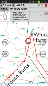
For navigation, the phone runs an app called MMTracker, which used to be available through the Google Play store, but was withdrawn a couple of years ago at the request of Memory Map who felt the app was infringing on their copyright. It is now available through the xda-developer website and well supported by members of their forum (use the link above).
MMTracker is still a great app, much better than the Memory Map app for Android, and the reason for the take-down request was because it reads Memory Map QCT files (these are the OS map files that Memory Map used to produce for the PC version of their product.). The app then uses the built-in GPS on the phone to place my location on the OS map on screen. This is fairly similar to lots of modern GPS devices, but is much more flexible. I have an Aquapac waterproof case to keep the phone safe if it rains.
Modern versions of Memory Map use a new file format that is not supported by MMTracker, so you’re either stuck with using the Memory Map Android app, or you can drop me a line if you’re interested in MMTracker.
Battery Management
One of the major criticisms of using a mobile phone for this sort of activity is battery life. I’ve seen a lot of postings on walking blogs and forums over recent years about battery life in smartphones being used on the hills. There are of course many reasons for battery drain and the more uses the device is put to, the faster the drain will occur and the less reliable it becomes as a navigational aid.
The problem is that smartphones drain their batteries quickly enough without adding a GPS mapping product into the mix, so what can we do to mitigate this? Here are a few tips I’ve picked up over the years I’ve been using this setup.
One of the best ways to preserve your battery life is to switch off the phone function, Bluetooth and WiFi. When you’re on the hills the network connectivity isn’t needed, so that’s a no brainer, but the phone function is also pretty much redundant while I’m walking. If I want to make a call I switch the function back on and make a call. At that time I can check for voice mails and text messages. In the very unlikely event that someone has tried to call me, I will call them back. It’s important to remember how mobile phones work. A phone regularly checks for the nearest cell tower, it does this less often when it has a good signal, it does this A LOT if it has no signal at all! The result is that in a remote location (like on the hills) a phone without a signal is almost constantly checking for a tower, and this has a dramatic impact on battery life. So if you know you’ll have no signal for a few hours, switch the phone function off. In most cases using Flight mode (as it’s called) will not prevent your GPS function from working.

Smartphones tend to have a number off apps installed, many of these are what PC engineers used to call TSR (Terminate and Stay Resident); that is once you’ve used the app it’s in memory and will probably stay there unless you specifically stop it (which is different to just closing it). A good Memory Manager app will help you identify these apps and kill them safely; Android and iPhones are as bad as each other here!
As a result I tend to reboot my phone before I start a walk. This means the phone is as virgin as it can be; as few apps running in the background as possible, as much free memory as possible and as little battery drain as possible.
None of these measures have impacted the phones ability to acquire and maintain a GPS signal. Modern smartphones implement an assisted GPS function that uses the phone signal and WiFi signals to help determine the GPS location. This means they can use location aware services even when you’re inside, out of direct line of sight from the GPS satellite network. However, they are not dependent on these services to get a GPS signal. They don’t need a phone signal to get a GPS lock or maintain it. Even in Flight Mode my Android devices have always been able to get a GPS lock, which may not be the case on an iPhone; it’s been a while since I used one, so you’d need to check this before heading out.
Another obvious measure is to reduce the brightness of the screen to an absolute minimum usable level. Screen time is one of the biggest single factors of battery drain and brightness is a killer. To reduce the time the screen is on, make sure you reduce the timeout setting as low as possible too, or train yourself to switch the screen off when you’ve finished with it.
As a result of these measures I can get about three days usage out of my Note 3 without it needing a charge. Even if I’m opening the device every few minutes and checking my location and direction, it’s still using so little battery for other activities that I get excellent life out of it.
One of the reasons I stopped using the iPhone was the difficulty I had keeping the device charged. I tried several different methods and none of them were particularly effective, lightweight or reliable. With the Android devices however, I can carry a spare battery and it takes just a few moments to swap them over. Weight for weight I can carry 3 or 4 spare Note 3 batteries compared to my charging solution for the iPhone. That’s about two weeks worth of phone life.

Splitting Responsibilities
I long ago stopped using my smartphone for listening to music while walking, or listening to audiobooks; both these activities are now performed by a dedicated iPod device (a tiny Nano). The weight penalty of carrying the iPod is more than compensated by the additional battery life I get from the phone. The battery life of the Nano is extraordinary as well, I can usually get 20 hours of usage before it needs a charge and even once the battery’s drained it’s not impacting anything serious.
I know that some people like to record their routes, in fact I’m one of them. I actually have a record of every single walk I’ve ever done since early 2006. Recording my tracklog on the smartphone, however, is likely to kill the battery in next to no time. I’d be surprised if I managed to record the track of a full day walk on my smartphone without draining the battery. So I decided to split responsibilities here too. I use the smartphone for what it does best; showing me the map, determining my current position and showing me where to go when I’m in doubt.
I use a device called a GPS datalogger to record my tracklog. The one I selected is a Blumax 4044. It’s about the size of a matchbox and weighs 59g. It has two modes of operation; logging and transmitting. In logging mode the device records your track and stores it as a GPX file in its internal memory. In transmit mode it makes the track available via Bluetooth to other devices. There is sufficient internal memory for several hundred miles of track.
I use it exclusively in logging mode. I get about 30 hours usage from the device, which is about 3 days of walking, all on a single standard Nokia phone battery. These batteries are very cheap, very light and easy to change. When I get home I connect the device to my home PC and download the tracklog.
I now have the best of both worlds; a long life smartphone GPS and a simple, effective tracklog recorder.
Building Redundancy
I’m an IT consultant by trade and one of the key things that gets drummed into you over the years is Backup. Always have a backup of whatever you hold dear. This is just as true on the hills.
I buy my phones outright so they aren’t locked into a specific network. This means I can change my phone when I want, but it also means I can slip any SIM card into the phone that I like. The SIM from my usual service provider is in the phone by default of course, but I also carry two spare SIMs from other networks, charged with £5 of credit. Having spare Orange and Vodafone SIMs will mean if there’s a signal to be had in the hills you’ll probably get it on one of these two carriers.
If your phone isn’t network unlocked, consider carrying a cheap mobile phone with a SIM from a different service provider, this will offer you some redundancy at least.
You can see Part 2 of this post here: Smartphone on the Hills part 2
10 thoughts on “Using a Smartphone on the Hills”
Just wondered if anyone had a any thoughts on this idea.
We have an iPhone App (Android development is going slowly but should be ready early 2014). Our developers have asked if we want the facility to connect a GPs tracker the the phone? The iFootpath App has a GPS tracker built in so we (and others) use it to create walks for our website and to follow back again through the App.
So is there any advantage in two way communication with a dedicated GPS device? I guess if your GPS device has OS maps it could be helpful for example?
Interesting and useful post. I have a Galaxy S1 and carry a couple of spare charged batteries – they are pretty cheap to buy and also quite light. But I would always have a map and compass too. The GPS can have moments of madness – my Active 10 once had me over 1km from where I knew I was and that lasted for an hour or so until the walk finished – the antenna was knackered apparently. My Galaxy has had me 100 metres or so out, which was potentially dangerous in the terrain and weather I was in that day. But generally they are brilliant at pinpointing your position. By the way you have a record of every walk since 2006? Good stuff – but my log of every hill walk goes back to 1975. Routes, times of each leg, weather, companions etc. I also have lists of every book read since then too. I have a weird penchant for lists 🙂
David (@FellBound)
Lists are great, but not as great as spreadsheets 🙂 I started life as an accountant and hated all of it, apart from the spreadsheets bit!
So far (touch wood) my GPS position has never let me down. Successive smartphones have better and better GPS antennas which means quicker locks and better accuracy.
I intend to take one of those compass and navigation courses, before I do my LEJOG next year. Spending weeks on end in the wilderness it would make sense to know how to use one.
Interesting, I will give it a go. Thanks!!
How do you turn off the phone function on the Samsung? I know you can set it to Airplane mode but I guess this disables GPS too?
With my Samsung Galaxy S2, switching into Airplane mode doesn’t switch off GPS, which I was initially surprised by, but most pleased I must say. Give it a go.
We have developed a GPS iPhone tracker for walkers – you can create a track and then add images and a description and add it to our website for publication. You can use the App to follow other people’s walks and then not get lost – but take a map too! We are called iFootpath so please google us or find us on Twitter.
Very informative. i am the opposite only use map and compass, but will be adding GPS with the Samsung Note.I also met Mathew Hillplodder on the Crowdecote social, updated me on the Samsung Note.Thanks for your advice.Cheers
I agree with you on the GPS bit, I started using one in 1997 and even though they weren’t very accurate in them days I never went out without it.. I now use an Etrex and I find that coupled with a map and compass I have all the tools I need to get around safely…
I dare say that if I wasn’t such a skin flint I would buy a smart phone and carry lots of batterys too.. The possibilities with smart phones are endless and I admire you for using one…
Thanks Jimmy, the smartphone is the evolution of the PDA I used to use, just lighter and more functional. I was walking with Matthew “Hillplodder” at the weekend and he’s using a Samsung Note, which has a huge screen. I will be investigating small tablets in the not too distant future I think – a 7″ Nexus would be pretty cool, if I could find some way of carrying it easily 🙂